 Live Music Archive
 Librivox Free Audio
 Metropolitan Museum
 Cleveland Museum of Art
 Internet Arcade
 Console Living Room
 Books to Borrow
 Open Library
 TV News
 Understanding 9/11
tv Caught on Camera MSNBC October 28, 2012 3:00pm-4:00pm PDT
3:00 pm

hi, everybody. good to have you with me. 6:00 on the east coast. this is how things are looking in delaware. the delaware coast is one of a number of places along the eastern sea board that is under this mandatory evacuation order. this residents have two more hours until 8:00 p.m. to evacuate to higher ground. good to have you with me. you are watching msnbcs live coverage of hurricane sandy. residents along the east coast are bracing for the arrival of a category 1 hurricane. this is a monster storm. look at the path of it, though. it is expected to bring not only hurricane force winds, but heavy rain and flooding and some
3:01 pm

possibly heavy snow in the higher elevations. hurricane sandy is responsible for at least 65 deaths in the caribbean. it is now beginning to bear down on the eastern coast. at this hour, the national hurricane center is warning sandy is expected to bring surge flooding to the mid-atlantic coast. flooding that is unprecedented. 50 million people living along the path of the hurricane packing winds 175 miles from the center of this storm. we are going to bring the latest from nbc reporters stationed up and down the sea board. first, the latest from dillen drier. what's changed over the last hour? >> unfortunately, nothing. nothing is changing in the path of the storm that is going to make it easier. you saw the video or live shot from delaware. it already looks ominous and the storm is so far away. it's 350 miles to the southeast of virginia beach.
3:02 pm
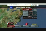
it's already starting to batter parts of northeastern north carolina and virginia and winds are picking up across delaware, maryland and new jersey as well. it's on the northeastward track at 15 miles per hour. it's expected to take a turn. atlantic city, new jersey, so far from the storm and wind gusts of 30 miles per hour. salisbury, maryland, 40-mile-per-hour wind gusts. the rain is going to continue to move on shore as the storm gets closer. conditions are going to deteriorate. portions of north carolina reporting wind gusts at 45 miles per hour. making our way up into delaware and new jersey and long island, we are winds gusting over 35 miles per hour. southern new england seeing gusts across cape cod up near 30 miles per hour as well. the storm is on the northeast track as well. because of the high pressure, it has nowhere to go but to the north and west. it makes land fall in central
3:03 pm
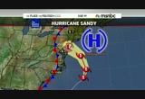
jersey or southern jersey or delaware. no matter where it hits, we are going to see the same effects. the tropical storm force wind extended 500 miles out from the storm. here is a time line for you. this evening, the surge is starting to build because of the high tide from north carolina, even up to new jersey. your typical low lying flood prone areas already see minor flooding. as we go into tomorrow morning, here you see the yellows indicate where we will see minor effects and more of a major effect. the surge will build at the high tide around 8:00 a.m. from virginia to long island. we'll see the flooding and beach erosion around coastal areas. wind damages and power outages near virginia, maryland and delaware will become an issue. the ground will continue to moisten up because of the rainfall and it's going to be a
3:04 pm
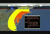
lot of stress on the trees and power lines. monday afternoon, the storm gets closer. we will see torrential downpours, flooding rain in inland area through delaware, maryland and new jersey. major wind damage is going to be an issue from southern new england to new jersey. look at the peak of the storm. this is monday night. we have a high tide between 6:00 and 9:00 p.m. it's when the storm is going to ramp up. that purple shade is where we could see historic damage. i hate to sound like it's hyping up this storm, but this is the way everything is shaping up. the storm coming from the east, pushing all that water on shore. we have an ast nom cal high tide. it's going to lead to a nine to ten foot storm surge. we will see historic wind damage with winds up to 80 miles per hour. as we go into tuesday, yes, the worst is over but we are looking at sustained winds up to 40
3:05 pm

miles per hour, gusts up to 60. more rain falls tuesday. it will take days for the power crews to get up and clean up the power outages. >> thanks so much. michelle franzen is live right now in the mandatory evacuation zone in lower manhattan area. it's battery park. it's what's considered in zone a. michelle, explain, have you seen more people trying to pack up and get out? >> reporter: we have, thomas, in the last few hours. battery park city sits at the southern tip of lower manhattan. it's a residential area. a lot of wall street here. you have tourist areas where people catch the cruises to go out to the statue of liberty. staten island and low lying areas fit into the category of zone a that mayor michael bloomberg said is evacuating.
3:06 pm

nearly 400,000 people are told to leave homes and hotels in the area. there are 76 evacuation shelters set up throughout new york city. of course the city and the state bracing for the absolute worst scenario here. much different than irene. we have seen people in the last few hours really taking this storm a little more seriously. also new yorkers taking it in stride. >> we have two children. 2 and under. so, it's a bit of a hassle. after going through what we did last year, we are glad the city is taking precaution. >> we are going up state a little bit. stay there a couple days. when they let us back down, we'll cobb back here. if i was young and sting l, we'd still be here. >> reporter: it's not just the mandatory evacuations taking place in the city. you have the subway system that will shut down. first of all, subways at 7:00 tonight. buses at 9:00. you have ferry service in the
3:07 pm

area that is shutting down as well. the port authority is taking steps to ramp down that construction at the world trade center sight, securing everything they can. broadway shows tonight going dark through tomorrow and perhaps tuesday. >> michelle franzen reporting from lower manhattan. thanks so much. hurricane sandy as we have been talking about. politically, it's an inconvenient time as the marathon is winding down. might be viqueira has more on this. the president came off the campaign trail to meet with the fema reps. >> reporter: it's interesting. the president had a very full day today. actually, he left a day earlier than planned to get back on the campaign trail. he left washington. air force one wheels up moments ago. the president going to florida. the trip was to take him to orlando, youngstown. the legs are on track.
3:08 pm

everything is tentative at this point with the travel. the third event was supposed to be locally here in virginia tomorrow night. that's been canceled. the president cannesling a trip to colorado the next day as well. romney had a couple things cancel. the president began his day coming out just behind me, walking across the street with his two daughters with their god mother attending services at st. john's church. the president hasn't been home much lately. time with his family. the walk across the park on a dry morning here in washington. he went down into southwest washington, visited fema headquarters, asked a lot of questions. we listened to him here. the audio here in the white house. he asked about snowfall in west virginia, how long it would take to get power restored. all the way to the ohio valley, he was told. then he emerged before cameras
3:09 pm

and made a lengthy statement. we are going play it for you now. >> good afternoon, everybody. obviously, all of us across the country are concerned about the potential impact of hurricane sandy. this is a serious and big storm. my first message is to all the people across the eastern sea board, mid-atlantic going north that you need to take this very seriously and follow the instructions of your state and local officials because they are going to be providing you with the best advice in terms of how to deal with this storm over the coming days. we just had an excellent meeting with the fema team here, the various agencies that are in charge, including the department of defense, the department of energy and others that are going to need to respond quickly. under craig fugate's leadership at fema, we spoke with the
3:10 pm

regional people as well. i had a phone call with the governors of the potentially affected states. at this stage, everybody is confident that the staging process, the prepositions of resources, commodities, equipment that is going to be needed to respond to the storm is in place. as craig has emphasized, this hasn't hit land fall, yet. we don't yet know where it's going to hit, where we are going to see the biggest impacts. that's exactly why it's important for us to respond big and respond fast as local information starts coming in. i want to thank all the members of the team for the outstanding work they are doing but the other thing that makes this storm unique, as we anticipate it is going to be slow moving. that means it may take a long time not only to clear, but also to get, for example, the power companies back in to clear trees
3:11 pm

and to put things back in place so that folks can start moving back home. so, my main message to everybody involved is that we have to take this seriously. the federal government is working effectively with the state and local governments. it's going to be very important that populations in all the impacted states take this seriously, listen to your state and local elected officials. my message to the governors, as well as to the mayors is, anything they need, we will be there. we're going to cut through red tape. we are not going to get bogged down with a lot of rules. we want to make sure we are anticipating and leaning forward to making sure we have the best possible response to what is going to be a big and messy system. again, thank you everybody. >> reporter: thomas at the conclusion of the remarks, a reporter asked whether the storm was going to affect the
3:12 pm

election. the president said i don't anticipate it at this point, but obviously, we have to look at one more thing. craig fugate was sitting next to the president's side. he admonished his aids at fema who said everything is under control. fugate said don't get smug, don't get overconfident. we don't know what is going to happen. obviously an incredible amount of federal and state resources geared toward what's going to happen on the east coast. >> a lot of moving parts. thanks. it's not too often we hear the words philadelphia and hurricane mixed in the same sentence. hurricane irene moved, big, powerful storms cause just as much destruction inland as they dump huge amounts of water and cause wind damage. the current storm track for hurricane sandy churning in the atlantic has it expecting to make a sharp left turn through the commonwealth of p.a. after
3:13 pm

it comes ashore tomorrow. this storm could be headed to philadelphia. michael nutter is the mayor of philadelphia. sir, i know that philadelphia has already gone under through your declaration a state of emergency. what does that mean for philly residents. >> the opportunity to talk about philadelphia. let me go back and say, it was a tremendous call that the president convened and previded over, he gave reassurance to all of us, the number of mayors on the call and all the governors up and down the east coast. the president's leadership on this issue is reassuring and he was very direct and very forceful, as you heard, about fema, the department of homeland security, administrator fugate and we are coordinating with them and certainly our governor here, corbett in pennsylvania. we saw it last year with
3:14 pm

hurricane irene, significant amount of rainfall in a relatively short period of time. not as high winds as anticipated. in this one, we are anticipating significant amount of rainfall in a short amount of time, four to eight inches of rain as you mentioned, as the president mentioned, slow moving storm. also, the prospect of winds and wind gusts of plus 50 miles an hour. that is significant. it's a great northeastern city which is one of our great qualities. one of the challenges is, it's a great northeastern city with old infrastructure, tons of trees and power lines. all of that can be affected by a storm like this. we are geared up and ready go. partnered with the state and federal government and all forces on the ground. this is all hands on deck. city government, except
3:15 pm

emergency personnel is closed tomorrow. schools are closed, public schools, catholic schools and charter schools. buses will end at midnight no later than 2:00 a.m. on monday. we are ready take the storm. citizens know what to do, how to do it. we are going to be with them every step of the way. >> you are saying bus and rail, the public systems are shutting down at midnight tomorrow night or tonight? sunday to monday or monday into tuesday. >> sunday into monday. midnight tonight. when those runs have gone to their conclusion, some are between midnight tonight and 2:00 a.m. that will be the end of all service here in philadelphia. there will be no mass transit service in philadelphia tomorrow. there's no school tomorrow. the city government will be closed with the exception of
3:16 pm

essential emergency or first responder designated personnel to come in. we are taking this very, very seriously. it is raining right now. not significant. it will pick up in the course of the night and into tomorrow. we'll get the heaviest rain and that combination of high winds. it's a full moon so significantly higher tide in the delaware. we are concerned about those rivers, creeks and streams in philadelphia as well. >> mayor michael nutter, thank you so much. we have deployed resources up and down the eastern sea board to have sandy covered. the coming land fall of this hurricane, reports from north carolina to connecticut as msnbcs extended coverage continues. we are back after this. [ male announcer ] alka-seltzer plus presents the cold truth. i have a cold... i took dayquil, but i still have a runny nose.
3:17 pm

[ male announcer ] truth is, dayquil doesn't work on runny noses. what? [ male announcer ] it doesn't have an antihistamine. really? [ male announcer ] really. alka-seltzer plus cold and cough fights your worst cold symptoms, plus has a fast acting antihistamine to relieve your runny nose. [ sighs ] thank you! [ male announcer ] you're welcome. that's the cold truth! [ male announcer ] alka-seltzer plus. ♪ oh what a relief it is! ♪ [ male announcer ] try new alka-seltzer plus severe allergy to treat allergy symptoms, plus sinus congestion, and pain.


3:20 pm

it appears the worst case scenario connecticut is the one that is likely to play out in the coming days. we are talking about an extended, unprecedented weather event that will begin tonight and extend through midday on tuesday. we are talking about extensive flooding. maybe the worst that we have seen in 70 years. >> welcome back. governor malloy of connecticut talking about hurricane sandy. another bad news situation being discussed is the election that is nine days away. what does this mean? early voting days, some states are in jeopardy. this morning, rachel maddow discussed it with david gregory. take a look. >> how much of this is a problem in terms of how people feel. we see economic optimism in the country and people are feeling
3:21 pm

like the obama record is lackluster and you look at it's not robust enough. >> you can see consumer confidence numbers trending up. the unemployment rate trending down. the deficit is dropping year to year. you see things going in the right direction. people have to decide if they want to switch horses and go with a guy that has a different way to go. it's a more european style way of going. >> the country thinks we are in the wrong direction. i think the most likely out come is they reelect all the same people. we get the same government we have had for four years. the case that has to be made is we have a rotton tax code. how you going to change that? i haven't seen obama do the change agenda. i have seen romney make gestures at it, but not lay it out.
3:22 pm

i think it would make a change hungry country -- >> that was rachel maddow and others discussing the upcoming election. joining me now is one of the co-hosts of msnbcs "the cycle." he writes for salon.com. good to have you here. as we talk about what we saw on "meet the press," voters acknowledge the economy is getting better. as we see the unemployment numbers go down and waiting for the friday jobs report coming out this friday, why do you think it doesn't resinate with the voters? >> it's been tough to figure out. on a certain level, they do recognize it. if you look at the polls, more people are saying we are better off than four years ago. more saying we are going to be better than we are now. there's rising optimism. at the same time, obama standing against romney on the question
3:23 pm

of who would manage the economy better deteriorated. in september, they were tied. polls have romney ahead mid to high single digits. the only thing i can conclude is the recovery hasn't taken ahold where people feel it. it leaves a lot of opening for people to say yeah, it's better, but it should be a lot better. >> did the president overpromise in '08, get into the white house and say holy smokes, i didn't realize how bad it was? >> he began in early 2007. nobody knew what he was going to confront until 2008. it was on the reality that never existed. it's the nature of these financial finance sector recessions where they are slow, they are prolong to get out of. i think from the minute he was elected, it was going to be dicey if he was reelected.
3:24 pm

it's not like an '80s recovery. >> you say the basic ingredients for the winners legacy may already be in place. what do you mean by that? >> we have positive indicators, housing is up, jobless claims going down. finding a real recovery is taking hold. whoever wins the election is going to get credit two or three years from now overseeing a recovery. a long term memory doesn't exist. if romney is elected, he may not do anything in terms of a policy. he may extend the bush tax cuts, but not a big economic blueprint. i think they will get credit for romney recovery. if he's president two or three years from now, numbers will rise. >> we recently watched mitt romney talking about jobs, jobs,
3:25 pm

jobs. 12 million jobs plan. moody's predicts that's already going to happen. cbo said that number is going to happen. i think they downgraded it to be 10 million to 11 million jobs that are going to happen over the next four years. >> no. it points to, you know, we will draw lessons from whoever gets elected, probably incorrect. >> what kind of lesson? this is the kind of thing the economics, you have to reduce tax rates on the wealthy because it will trickle down. if a recovery is already in the works and romney gets elected and this is the first act of the romney presidency, take the tax cuts for the wealthy. you can imagine two to three years from now, if it's down 6%, this will just become the way reagan did. romney will become gospel for generations. this is why we want low tax
3:26 pm

rates. if romney is elected and the bush tax cuts are extended, it doesn't have anything to do with that. it has to do with where the economy is now. i don't know they would recognize that. >> steve, good to have you in here. i appreciate your time. >> sure. >> stick with us. hurricane sandy is not just this ordinary cat 1 storm. its size and the weather patterns coming from the west are making this interesting. the tides, because of the full moon tomorrow night make the worst case scenarios extremely likely. the latest coming up as hurricane sandy watch continues. oh no, not a migraine now. try this... bayer? this isn't just a headache. trust me, this is new bayer migraine. [ male announcer ] it's the power of aspirin plus more in a triple action formula to relieve your tough migraines. new bayer migraine formula.


3:29 pm

welcome back, everybody. residents in delaware prepping for hurricane sandy. time is running out before this evacuation order of this coastal state goes into order. beaches to rehoboth beach will close in 90 minutes from now. at 7:00 p.m. new york city's
3:30 pm

transportation system will begin shutting down for prep president obama called big, serious and slow moving. i want to bring the latest from dylan drier. not a lot of changes. nothing is happening. it's a massive, big and lumbering. >> that's the problem because it is so massive and big and lumbering, as you called it, the storm, no matter where it goes is going to wreak havoc. we have been talking about this storm, putting it in terms of unprecedented, historic, something we have never seen before. there are quite a quu factors of why we can say that with a definitive stance on it. here it is. this is the size of the storm in ohio and pittsburgh. it's a frontal system that's moving from east to west. it's drawing in this storm and the storm itself is still more than 300 miles to the east of the carolinas. cape hatteras dealing with
3:31 pm

torrential rain. gusting winds 40 to 50 miles per hour and the storm is still 300 miles away. we stress that point because imagine how strong the winds are going to be as it gets closer to shore, which is going to happen as we go into monday night. you have a dip in the jet stream. a hurricane develops. it's no threat anywhere across the eastern sea board. it's a typical situation. this time around, this is part of the reason why we are calling it historic and unprecedented. we have a huge blocking high over green land where the storm can't go off to the east. it gets pinched and pull sbood the shoreline of new jersey or delaware or wherever it hits in the mid-atlantic. it doesn't matter. it's no longer going to be a hurricane. it's a post-tropical storm. almost a hybrid. it's transforming into something like a nor'easter. we call it a hybrid storm and
3:32 pm

have no actual name for it, nothing to term it. there's something just unusual about the whole development of this storm. look at the size of the storm. tropical force storms. we have tropical force storm winds from new hampshire to north carolina. you can see the huge swath of wind doesn't shrink that much as it makes land fall. whether it hits in new jersey or delaware, it can hit in virginia and new england. the winds are extending so far out from the center of the storm. combining this, why is it an unusual storm? it's one of the largest ts force windshields on record. you don't talk about them with the winds extending that far out from the center, winds 40 and 50 miles per hour.
3:33 pm

gusts up to 80 miles per hour. there's a sharp east to west track with the high pressure system. most storms don't move from due east to practically due west. it's a very strange motion it's making toward the shoreline. it's pushing all the water on shore. you have the normal high tide cycle on monday night. on top of that, a four to seven, eight, nine, ten foot surge possible. it's a wall of water that is going to move on shore. coastal flooding will be an issue. it starts as a cyclone and turns into a nor'easter. on the backside of it, even the front side, seeing blizzard warnings across west virginia. three inches of snow has fallen in west virginia. you have the tropical moisture creating mountain snow back through west virginia throughout almost the duration of the storm. we will see up to a foot of snow in regions across west virginia
3:34 pm

in the highest elevations. there are a lot of factors going into this storm. what you need to know, tomorrow conditions are going to deteriorate rapidly across the mid-atlantic even virginia. the rain will continue. we are looking at winds to gust up to 80 miles per hour monday night. power outages, long duration power outages will be an issue, even beyond tomorrow night. tuesday and wednesday, it's going to take days for the power crews to clean this up. thomas. >> this massive storm. it's got a lot of attention from state governors. ten state that is put states of emergency into effect. it's being felt from the carolinas to new england. we go to new england where reynolds wolf is reporting. connecticut is no changer to having issues with power outages. i talked specifically about last year dealing with irene. it's because they have old
3:35 pm

school power lines and issues with the trees knocking them down with the high winds coming in. >> reporter: absolutely, thomas, you are right. they are no stranger to power outages or strangers to the sea. it goes back to 400 years of nautical history. long ago, they have a love/hate relationship with the sea. the sea can provide, but also take away. when a storm of this magnitude comes calling, they take it seriously. let's go back in time with video from earlier in the day. you can see, plain as day, people out about in the sea port doing what they can to tie the boats in, giving them slack. when the waters come in, we expect them to rise, the boat haves to do what they do best, that is float. the water rises up. you can see other preparations they have around the docks. it's going to be a long haul. this is not going to be a quick trip. this is going to be a long term
3:36 pm

event. we have 24 to 36 hours easily in the region. then the power outages. let's come back to me. as we come back, i want to talk about something we have been mentioning all day. it's the flooding. we have worked together. i'm kind of a tall guy. we had irene come through here, it was ankle height. with this one, we expect the storm surge to be higher. the water comes to long island. the coastline is going to rise up. harbors like this one. we expect with the full moon and the rising tide that the water could get up to four feet in some places. that's up here on me. remember, i'm a tall geek. something else to consider, this is what you started with, thomas. the strong winds. tropical storm force winds by monday night and spilling into tuesday. some winds in excess of 70 miles per hour. we might see gustins up to 80
3:37 pm

miles per hour. on the far side of the water and all through mystic, quite a few leaves. they provide air resis tans. when you have the winds come through, those trees, many of them were weakened back in irene. they could get knocked over and break power lines. when they break the power lines, the old ones you were talking about, thomas, you are going to see power outages that affect not just thousands, but millions throughout the region. it could last for days and weeks. back to you. >> with irene, they were without power, millions of people for weeks. i know you are a tall guy. your waiters are probably not far away from this live shot. good to see you. reporting from mystic, connecticut. we want to go south where the latest forecast models for hurricane sandy have the most likely path along the new jersey coastline. jay gray is in cape main, new
3:38 pm

jersey. how have things changed since the last time we got to speed? >> hey, there, thomas. the wind died down a bit. it's good news. what's changed in this jenn-air ya, people are about done with the preparations, which is good news. the time to do that is quickly running out. look, these conditions aren't bad. as we have been talking the last several days, it's going to get worse, the next 24 hours. that's why the emergency officials are saying the time to prepare is running out in the strike zone. sandy is already started to batter the east coast. violent winds, driving rains and a growing surf. >> it's a serious storm. >> reporter: so far, only a glance as the storm comes up the coastline and prepares to make a left turn slamming into the jersey shore late monday. >> of the states impacted by the storm, we appear to be taking the brunt of it. so, we have to take this
3:39 pm

seriously. >> reporter: many in the potential strike zone understand, the window of opportunity to prepare is closing fast. >> they call it frankenstorm. it has us nervous. >> reporter: nerves are on edge along the eastern sea board. >> scared and worried. >> reporter: and working to do what they can before the storm hits. boarding up and putting up anything they can. stocking up on supplies that may be needed to ride out a week or more without power. mandatory evacuations continue in coastal communities across several states. at least 375,000 have been evacuated from their homes in lower manhattan. public schools will be closed and public transportation will be suspended until conditions ease. >> we have a plan to keep new york safe and recover as quickly as possible. >> reporter: as fema and the white house continue work on a national response plan.
3:40 pm

>> we want to make sure we are anticipating and leaning forward to make sure we have the best possible response of what is a big and messy system. >> reporter: a mess that's already started and could linger on the atlantic coast for days. look, thomas, you talked about it. you have to keep repeating this. this is a massive storm. it's a slow mover. not only are the winds going to be a problem, but the rain could fall for 36 hours. it's too much water for communities like this one to bear and others along the atlantic coast. then add in the surge, which is expected to be dramatic. flooding is going to be an issue, the lack of power. this is a problem that's going to stretch out for quite some time. a rough go. >> jay gray in new jersey. thanks so much. as jay is pointing out, certain areas along i-95 are bracing for the worst here. it is the second year in a row
3:41 pm

they had to get used to this rarity of a hurricane this late in the year. folks in new york city are not supposed to be in hurricane city. what they are doing to get ready for a massive wind and rain event. much more when we come back. this is our continuing coverage of hurricane sandy.
3:42 pm

ally bank. why they're always there to talk. i love you, james. don't you love me? i'm a robot. i know. i know you're a robot!
3:43 pm

but there's more in you than just circuits and wires! uhhh. (cries) a machine can't give you what a person can. that's why ally has knowledgeable people there for you, night and day. ally bank. your money needs an ally.
3:44 pm

welcome back. let's get to west trenton, new jersey. governor chris christie is giving an update for his state. >> again, we can't emphasize this enough. don't go out there and try to be hero and act as if nothing is going on. it's important. we need to have you stay inside for the day tomorrow. tomorrow will be -- tomorrow and tomorrow evening will be the worst times of the storm. state government offices will be closed tomorrow with the exception of emergency personnel
3:45 pm

involved in emergency and response. state government staff should stay home tomorrow. please stay home tomorrow. as i said earlier, school openings are made at the local level. they have been conducting conference calls today with county superintendents of schools regarding decisions to close schools. of the 590 school districts statewide, as of 20 minutes ago, 350 of those districts decided to close tomorrow. 247 have decided to close on tuesday. so, that's updated as of about 20 minutes ago. 350 of our 590 school districts made the decision to close. 247 of those decided to close on tuesday. to make it easier for those of
3:46 pm

you in coster, mercer and salem counties the schools decided to close for monday and tuesday. if you are listening to me in gloucester, your children will not go to school monday or tuesday of this week. new jersey transit implemented a systemwide shut down of bus, rail, light rail and access link service starting at 4:00 p.m. this afternoon and continuing through the course of the evening. amtrak will suspend service at 7:00 p.m. path service will be suspended at midnight tonight. i want to make sure that everybody keeps all this in perspective. we are expecting a significant storm here that could lead to significant flooding. the latest updates we have change the land fall zone a little bit from where we were
3:47 pm

earlier this afternoon when i was up in passat county. this is, again, a moving target. unfortunately, the movement now means more flooding rather than less flooding in parts of the state. this is something we are going to have to continue to follow. this is going to be a significant event. it's an event that is going to unfold over a period of time. it's not going happen and go away. you are going to see some of it tonight. you are going to see some of it tomorrow morning and by tomorrow evening, the combination of the rain for that period of time, the flooding and the winds are going to make this a difficult thing to deal with, traveling on the roads and all that. be prepared to stay home and to stay safe during that period of time. we'll continue to update folks on a regular basis and i'll take questions from the press that are here. i'll turn it over to the colonel
3:48 pm

for brief remarks. we are not going to go every everything again. the members of the cabinet, be brief and not repeat things we said at 1:00 and earlier this morning as well. i'll come back and answer questions. >> thank you, governor. i'll update you on the latest forecast discussion with the national weather service less than an hour ago. a slight track of the storm. the state remains in the cone of involvement. it looks like atlantic county and perhaps this prediction is drifting back and forth. the range is where land fall is going to occur. by 2:00 a.m. tuesday, a little past land fall, which is going to be overnight tomorrow night is west of atlantic city and moving west, northwest on the present track. the beaches are going to be very
3:49 pm

bad with eight to 12 feet waves monday to monday night. i would have to say all through monday, we are dealing with threeastronomical sides. each one of these consecutively will be worse than the previous one. the worst of the coastal flooding will be north of the land fall. so, that would encompass the counties i pointed out, up to new york bay and the harbor area. four to eight feet -- >> listens to officials there including governor chris christie of what new jersey is preparing for, hearing about the moving target, the land fall zone of where sandy should come ashore. the prediction is anywhere from monomouth county. as of tomorrow, 350 of the 590 school districts closed.
3:50 pm

247 of the 590 school districts closed for tuesday. they are making major preparations to stay ahead of the storm. the only people that will be working tomorrow as we know are emergency personnel. they are along the coastal state of new jersey. when we come back, we turn to the other side of the hudson river. the new york subway is about to be shut down. we'll talk live with the chairman of the transit authority. we are back with much more after this. you have copd like me, you know it can be hard to breathe, and how that feels. copd includes chronic bronchitis and emphysema. spiriva helps control my copd symptoms by keeping my airways open for 24 hours. plus, it reduces copd flare-ups. spiriva is the only once-daily inhaled copd maintenance treatment that does both. spiriva handihaler tiotropium bromide inhalation powder does not replace fast-acting inhalers for sudden symptoms. tell your doctor if you have kidney problems, glaucoma,
3:51 pm

trouble urinating, or an enlarged prostate. these may worsen with spiriva. discuss all medicines you take, even eye drops. stop taking spiriva and seek immediate medical help if your breathing suddenly worsens, your throat or tongue swells, you get hives, vision changes or eye pain, or problems passing urine. other side effects include dry mouth and constipation. nothing can reverse copd. spiriva helps me breathe better. (blowing sound) ask your doctor about spiriva. [ male announcer ] it started long ago. the joy of giving something everything you've got. it takes passion. and it's not letting up anytime soon. at unitedhealthcare insurance company, we understand that commitment. and always have. so does aarp, an organization serving the needs of americans 50 and over for generations. so it's no surprise millions have chosen an aarp medicare supplement insurance plan,
3:52 pm

insured by unitedhealthcare insurance company. like all standardized medicare supplement plans, they help cover some of the expenses medicare doesn't pay. and save you up to thousands in out-of-pocket costs. to find out more, request your free decision guide. call or go online today. after all, when you're going the distance, it's nice to have the experience and commitment to go along with you. keep dreaming. keep doing. go long.
3:53 pm

today, i am announcing the mta will suspend bus, subway and commuter rail service at 7:00 p.m. this evening. >> welcome back, everybody. governor andrew cuomo announcing
3:54 pm

something that almost never happens. it's going to happen at the top of the hour. officials are going to start shutting down the massive new york city public transportation system at 7:00 sharp. the last time they did this was 14 months ago for hurricane irene when surges were smaller than feared. new york area airports are expected to close this evening. amtrak is cancelling trains. we believe tomorrow as well. joseph lhota is chairman and board for the mta. mr. lhota, it's good to have you with us today. let's talk about this transportation system that is beginning to shut down. explain how quickly this is all going to happen. do people have time to try to get home if they are trying to make that 7:00 p.m. curfew? >> we told customers yesterday there was a very, very distinct
3:55 pm

possibility there would be a suspension of service starting at 7:00. it's not an automatic suspension of service. we are going to bring all trains into the terminal. it will be completely shut down by 3:00 a.m. in the morning. i have told folks out there, the most important thing, if you need to get home tonight to try to be on a train by 7:00 p.m. after this time, we are not guaranteeing that they may be able to get on to a subway train. we are going to have our buses, however, they will start suspension two hours from now at 9:00 and we'll begin that process. >> when you say the buses start at 9:00, the trains stationed and shut by 3:00 a.m. officially, how long will it take to get the public buses off the road? >> 3:00 a.m. is the same torgt. >> same target. so, when this shutdown happens and everything goes into effect, what is the start up to get everything back up and running,
3:56 pm

if you feel the worst is passed? how long will it take? >> here is what we have to figure out, how severe the surges are. if we have salt water down in the lower manhattan area and the subway system down in lower manhattan, it's going to take awhile to get the water out. once all the water is out, we'll be up and running around 12 hours later. if we have power outages in the new york area, anywhere along the lines, the subways run on electrical power. we need that to operate. it's critical. right now, i'm trying to caution everyone to get back to normal is going to require 12 hours after we have full power and we clean everything out. it's going to take longer than that. >> joseph lhota, thanks for taking time out for us. we appreciate it. >> thanks. a gray and ominous day has given way. the wind and rain is making its
3:57 pm

way northward. we are going track hurricane sandy as msnbcs extended coverage continues into the top of the next hour. we have reporters stationed along the eastern sea board. we are back with much more after this. that was me... the day i learned i had to start insulin for my type 2 diabetes. me... thinking my only option was the vial and syringe dad used. and me... discovering once-daily levemir® flexpen. flexpen® is prefilled. doesn't need refrigeration for up to 42 days. no drawing from a vial.
3:58 pm

dial the exact dose. inject by pushing a button. flexpen® is insulin delivery... my way. levemir® (insulin detemir [rdna origin] injection) is a long-acting insulin used to control high blood sugar in adults and children with diabetes and is not recommended to treat diabetic ketoacidosis. do not use levemir® if you are allergic to any of its ingredients. the most common side effect is low blood sugar, which may cause symptoms such as sweating, shakiness, confusion, and headache. severe low blood sugar can be serious and life threatening. ask your healthcare provider about alcohol use, operating machinery, or driving. other possible side effects include injection site reactions. tell your healthcare provider about all medicines you take and all of your medical conditions. get medical help right away if you experience serious allergic reactions, such as body rash, trouble with breathing, fast heartbeat, or sweating. with flexpen®... say good night to vial and syringe. ask your doctor about levemir® flexpen. covered by 90% of insurance plans, including medicare. find your co-pay at myflexpen.com.

84 Views
IN COLLECTIONS
MSNBC West Television Archive
  Television Archive News Search Service
Uploaded by TV Archive on
